


Discover Bermuda and Explore the Fossils & Geodiversity of the Western North Atlantic
- 4 hours ago
- 6 min read
Bermuda is a remote island system described as an unique pseudo-atoll in the western North Atlantic, formed atop an extinct volcanic seamount that prevents subsidence. Its landscape features wind-cemented carbonate dunes known as eolianites, coral reefs, and limestone karst formations that preserve over one million years of Pleistocene environmental change. Key formations include the Walsingham Formation (over 700,000 years old) and the Belmont Formation (~200,000 years old), which contain fossil coral reefs, marine molluscs, and endemic land snails of the genus Poecilozonites. Cave systems like Admiral’s Cave have yielded extinct flightless birds, Audubon’s Shearwater, Bermuda Petrels, reptiles, and ancient land tortoises of Hesperotestudo bermudae. Marine and terrestrial fossils, combined with fossil soils (palaeosols) and karst features, reveal past interglacial warmth, sea-level change, dune migration, and island ecosystem evolution, making Bermuda a globally significant destination to understand the influence of volcanism, carbonate deposition, Quaternary paleoecology, and island biogeography.

Rising dramatically from the deep waters of the western North Atlantic, Bermuda stands apart from nearly every other island system on Earth. It is neither a fragment of continental crust nor a classic volcanic chain like Hawaii. Instead, Bermuda represents a rare geological hybrid of a carbonate platform constructed atop an extinct mid-ocean volcanic seamount, often described as a “pseudo-atoll.” Isolated roughly 1,050 kilometres east-southeast off the coast of in North Carolina, the islands sit far from active plate boundaries and major sediment sources, preserving an exceptionally clear record of volcanism, reef growth, wind-driven sedimentation, and climate-driven sea-level change.
Bermuda occupies the western margin of the Bermuda Platform, a shallow carbonate shelf resting on the North American tectonic plate. Today’s landscape is dominated by cemented sand dunes known as "eolianites" a limestone formed when wind-blown marine shell sand accumulated into towering ridges and later hardened through natural cementation.

Carbonate eolianite dunes forms some of the world’s most distinctive coastal landscapes, particularly across mid-latitude continents and islands, with most deposits dating to the Pleistocene Epoch of the Quaternary Period. Long-term records from South Australia’s Coorong coastal plain reveal repeated phases of dune accumulation during interglacial and interstadial sea-level highstands when global sea levels were significantly higher than they are today, while classic island systems such as Bermuda and the Bahamas show a close link between carbonate dune growth and rising seas since the Middle Pleistocene.
In contrast, some eolianites developed during glacial periods through wind reworking exposed shelf sediments and low-sea-level shorelines. These ridges are characterised with fossil soils and carved by extensive karst systems produced by the chemical dissolution of limestone.

Beneath this young surface lies a far older volcanic foundation that began forming in the Late Cretaceous to early Cenozoic, with major eruptive activity peaking around 30 to 33 million years ago. Some 700 metres deep, Bermuda reveals thick sequences of basaltic lava flows and intrusive sheets forming the volcanic basement.

Bermuda’s volcano was originally thought to be a classic mantle hotspot, similar to the plume that feeds Hawaii. However, recently deep core samples have revealed that the magma originated from a mantle transition zone was likely mobilised by an ancient tectonic subduction zone rather than a narrow thermal plume. This discovery introduced a previously unrecognised mechanism of intraplate volcanism or volcanic activity that occurs within the interior of tectonic plates, rather than at their boundaries. This discovery has help to shape our understanding of how isolated oceanic islands can form.
When volcanic activity ceased about 30 million years ago, wave erosion rapidly flattened the island to sea level, producing a broad, flat-topped seamount. Warm, shallow waters then encouraged the growth of coral reefs, calcareous algae, molluscs, and foraminifera that all generated enormous volumes of carbonate sediment. Over millions of years, their skeletal remains accumulated into thick blankets of limestone, gradually burying the volcanic core beneath a thick carbonate platform.

Loose carbonate sediment was transformed into solid rock through diagenesis the chemical and physical processes that cement grains together after deposition. Rainwater filtering through porous dunes dissolved unstable carbonate minerals and redeposited them as calcite cement, progressively strengthening the deposits. What were once mobile sand dunes became the durable stone that now forms Bermuda’s landscape.
Most of Bermuda’s exposed rock belongs to the Quaternary Period, especially the Pleistocene Epoch between about 2.6 million and 11,700 years ago. During this interval, Earth’s climate swung back and forth repeatedly between cold glacial phases and warm interglacial periods. As massive ice sheets expanded and melted, global sea levels rose and fell driving a rhythmic alternation between reef growth and dune formation across the Bermuda Platform.
When sea levels were high during interglacial periods, coral reefs flourished and shallow marine sediments spread across the flooded shelf. When seas fell during glacial phases, vast beaches emerged, and strong trade winds swept carbonate sand inland, building immense dune systems. Repeated wetting by acidic rainfall lithified these dunes into eolianite ridges that mark a former shoreline posit.
Interbedded between these dune formations are thin but striking fossil soils known as terra rossa palaeosols or Big Red Soil. Rich in iron oxides and clay, their reddish-brown colour reflects prolonged landscape stability lasting tens to hundreds of thousands of years. These soils formed when Bermuda once emerged as a much larger forested landmass during a phase of low sea-level.

As acidic water percolated through these ancient soils, it dissolved the limestone beneath, producing irregular karst surfaces riddled with pits and vertical tubes known as soil pipes interpreted as decayed palm tree moulds known as “palmetto stumps” from Sabal bermudana a species of palm tree endemic to Bermuda.
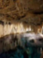
Bermuda’s limestone is a succession of five major formations that collectively record at least seven glacial–interglacial cycles. The Walsingham Formation on Bermuda is the island’s oldest and hardest limestone unit, dating to over 700,000 years ago, forming dense, highly altered Pleistocene limestone between Harrington Sound and Castle Harbour and hosting extensive cave systems such as Crystal Cave that developed during lower sea-level conditions. Above it lays the Town Hill Formations, followed by the Belmont Formation at roughly 200,000 years, the Rocky Bay Formation around 120,000 years, and the youngest Southampton Formation dating to about 80,000 years.

Among these, the Belmont Formation is of exceptional global significance. It preserves fossil coral reefs linked to Marine Isotope Stage 11 (MIS 11) representing one of the longest and warmest interglacial periods of the Quaternary, spanning roughly 424,000 to 374,000 years ago, and stands out for its exceptional climatic stability and high global sea levels. Often reaching 6–13 metres above present levels, MIS 11 drove widespread coral reef growth, coastal limestone formation, and shoreline development in regions such as Bermuda, the Bahamas, and the Mediterranean. Atmospheric carbon dioxide concentrations were comparable to or slightly lower than pre-industrial levels, yet temperatures remained remarkably high for nearly 30,000–35,000 years.
Along Bermuda’s south shore, coral heads remain preserved upright in their growth position, just as they lived hundreds of thousands of years ago. Their thickness and continuity indicate long-lasting warm seas and stable reef environments.

Bermuda’s fossil record provides a compelling window into the island’s Pleistocene ecosystems, revealing a landscape shaped by fluctuating sea levels, dune migration, and climate change over the last one million years. Dominated by marine organisms such as corals, molluscs, echinoids, and abundant microfossils,
Bermuda’s limestone formations also preserve remarkable terrestrial fossils. Fossil soils, or palaeosols, are rich with endemic land snails of the genus Poecilozonites, including the extinct P. nelsoni and the critically rare P. bermudensis. Cave systems, including Admiral’s Cave, have yielded bones of extinct flightless birds, Audubon’s Shearwater, Bermuda Petrels, reptiles, and the large ancient land tortoise Hesperotestudo bermudae, offering extraordinary insight into island evolution and extinction dynamics as rising seas reduced available habitat for terrestrial life.
Marine fossils, particularly shells of bivalves such as Lucina and gastropods like the West Indian Topshell (Cittarium pica), are abundant along the south shore and in formations such as the 120,000-year-old Rocky Bay Formation and the 200,000-year-old Belmont Formation.
Bermuda rests on a volcanic seamount stabilised by a thick layer of low-density underplated rock, preventing subsidence typical of classic atolls. Despite its remote location, historical earthquakes and faulting reveal the island’s tectonic activity, adding another dimension to its geological significance. Today, dramatic coastal outcrops, cave systems, and curated exhibits at the Bermuda Natural History Museum allow visitors to explore this rich archive, making Bermuda a globally important site for understanding Quaternary paleoecology, island biogeography, and the influence of volcanism, carbonate deposition, and climate-driven landscape change.