

Discover Canada and Explore the Fossils and Geodiversity of Prince Edward Island (PEI)
- Oct 10, 2025
- 4 min read
Updated: Dec 19, 2025
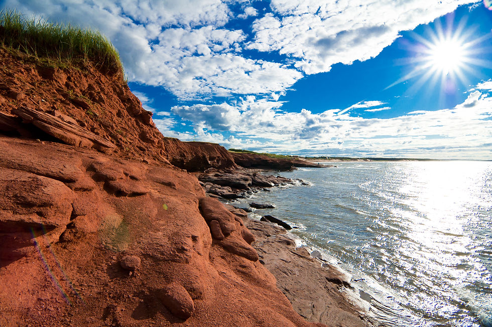
Sip back and discover Canada and explore the fossils and geodiversity of Prince Edward Island (PEI), Canada’s smallest province renowned for its striking Permian red sandstone coastal cliffs. Located in the Gulf of St. Lawrence, north of Nova Scotia and east of New Brunswick, Prince Edward Island is linked to the mainland by the Confederation Bridge the island stretches for approximately 224 kilometres. The red cliffs formed 255 – 300 million years ago during the Late Carboniferous to Early Permian, when rivers deposited iron-rich sands, silts and muds into the Maritime Rift within the Maritimes Basin a structural depression created after the Acadian orogeny. The iron content in the sandstone oxidised upon exposure, producing the vivid red hues visible today, which also inspired L.M. Montgomery’s Anne of Green Gables, particularly the fictional village of Avonlea modelled on the actual rural township of Cavendish. The island’s Pictou Group redbeds, include the Miminegash, Kildare Capes, and Hillsborough River formations and preserve a diverse fossil record, from Dimetrodon borealis to tetrapod trackways of the ichnogenera of Notalacerta and Gilmoreichnus, as well as plant fossils like Walchia and Paracalamites. These fossils reveal a tropical lowland ecosystem transitioning from a humid to an arid climate offering a rare glimpse into Early Permian terrestrial life in eastern Canada.

Prince Edward Island (PEI) is located on Canada’s east coast in the Gulf of St. Lawrence laying north of Nova Scotia and east of New Brunswick separated from the mainland by the Northumberland Strait. The island is connected to New Brunswick by the Confederation Bridge spanning nearly 13 Km that serves as its primary year-round link to the mainland. As part of the Maritime Provinces, Prince Edward Island is the smallest of Canada’s ten provinces in both area and population extending about 224 Km in length and varying between 6 to 64 Km in width. A defining feature of the Prince Edward Island coastal landscape is its Permian Redbeds of red sandstone formed around 255 – 300 million years ago during the Late Carboniferous into the Early Permian period as river and floodplain sediments deposited into the Maritimes Basin when the island lay near the equator on Pangea. These cliffs owe their vivid red colour to the oxidation of hematite the high iron content in the island’s sandstone bedrock when exposed to air. Interestingly, the Islands red cliffs, beaches and soil heavily influenced the Anne of Green Gables novels written by L.M. Montgomery where the fictional village of Avonlea was inspired by Cavendish, Montgomery’s own childhood home on the North Shore of Prince Edward Island.
Around 255 million years ago, fine sediments carried by rivers from distant highlands were deposited in a series of interconnected basins across the region known as the Maritime Rift. This rift system developed within the Maritimes Basin, a vast structural depression that formed when the supercontinent Pangea began to stabilise after the Acadian orogeny a major Devonian mountain-building event between 416 – 359 million years ago leading to the uplift, folding and metamorphism that formed much of the northern Appalachian Mountains and produced widespread deformation, metamorphism and plutonic intrusions across New England and eastern Canada.

The Permian redbeds of Prince Edward Island are part of the Pictou Group the youngest rock of the post-orogenic Maritimes Basin spanning from the Late Carboniferous into Early Permian. These sediments include the Miminegash, Egmont Bay, Kildare Capes, Hillsborough River and Orby Head formations formed by rivers draining from the ancient highlands to the south and southwest tropical lowlands of Pangea near the equator. Composed of iron-rich sandstones, mudstones, siltstones and arkosic wackes rich in feldspar from eroded igneous rocks from the mountains. The redbeds occur in a series of thick sequences up to 1,000 metres thick and tell a story of environmental change from the wetter Late Carboniferous to the drier more seasonal climates of the Early Permian.
Over time, these river borne sands, silts, and muds compacted and cemented into sandstone and siltstone. Subsequent uplift, weathering and glacial activity during the Pleistocene sculpted the island’s low hills combined with the environmental forces of wind, waves and storms the sea-facing cliffs eroded to produce spectacular coastal outcrops and revealed its fossils.
The fossil record of Prince Edward Island is remarkable for both its age and diversity dating from the Permian Period. The island’s most notable fossil is a pelycosauran reptile called Bathygnathus borealis now recognised as Dimetrodon borealis first discovered in 1845 at French River and represents the first vertebrate fossil named from Canada. Initially misidentified as a dinosaur jaw, later research confirmed that it was an apex sail-backed synapsid.

This fossil along with the fossil tetrapod footprints in the Pictou Group redbeds at Malpeque Bay and near Cavendish in Prince Edward Island National Park also show small stem-reptilian trackways assigned to the ichnogenera Notalacerta and Gilmoreichnus representing some of the island’s earliest terrestrial vertebrates.
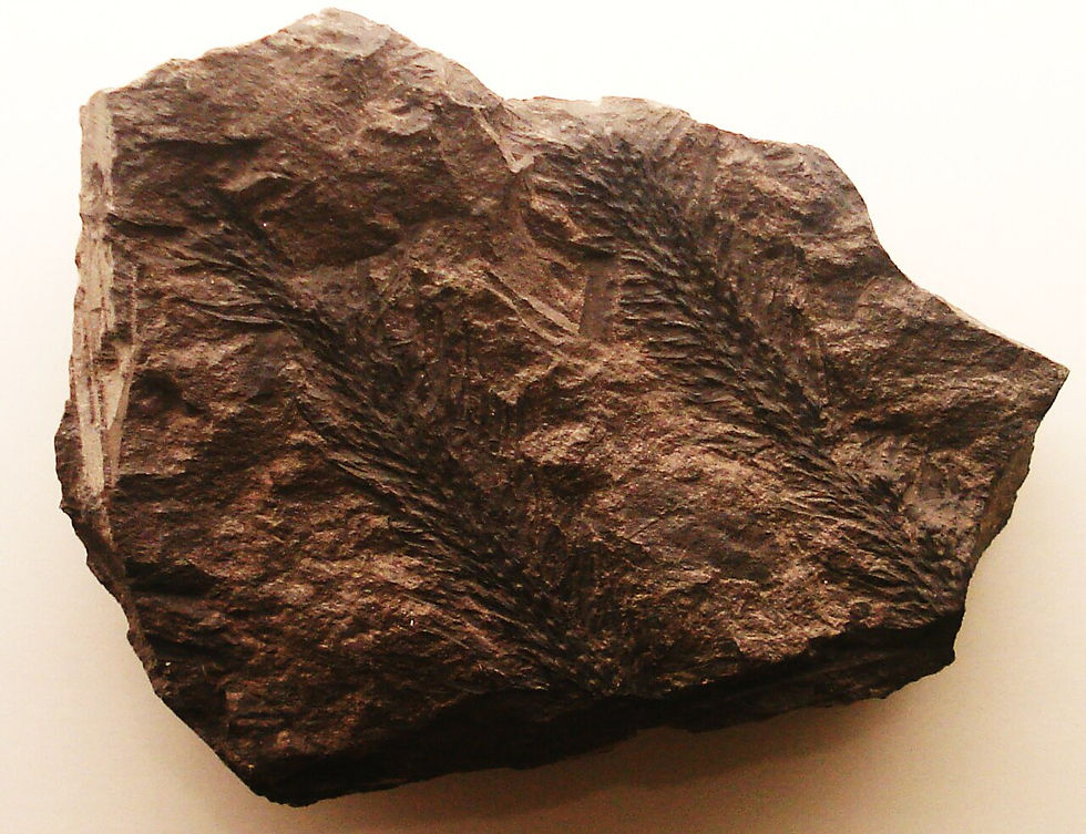
Plant fossils also include Giant Ferns, Horsetails, and conifer-like plants such Walchia, Paracalamites and Odontopteris. Together, these fossils reveal a tropical lowland ecosystem transitioning from humid to increasingly arid conditions offering a rare look into Permian terrestrial life in what is now eastern Canada.
Coastal erosion plays a crucial role in the continuing discovery of fossils on Prince Edward Island. The island’s soft sedimentary rocks are highly susceptible to weathering, and each winter storm exposes new layers of fossil-bearing rock is exposed. Fossil collection within the park is prohibited without a permit to ensure that specimens remain available for scientific study.
The fossils found on Prince Edward Island bridge a gap in Earth’s history linking the coal forests of the Carboniferous with the first reptile dominated landscapes that would emerge later in the Mesozoic.


