


Discover France and Explore the Fossils & Geodiversity of Massif des Bauges in Auvergne-Rhône-Alpes
- Nov 6, 2025
- 4 min read
Sip back and discover France and explore the fossils and geodiversity of the Massif des Bauges a UNESCO Global Geopark and Parc naturel régional in the northern French Alps. Rising dramatically between Lac d’Annecy and Lac du Bourget and straddling the departments of Savoie and Haute-Savoie. This striking limestone “rock fortress” preserves nearly 180 million years of geological history from Mesozoic marine sedimentation to Alpine mountain building. Its cliffs and ridges expose the Urgonian Limestone a rudist-rich carbonate platform formed in the warm, shallow seas of the Early Cretaceous Tethys Ocean. These ancient reefal limestones record a thriving marine ecosystem. Later, the Alpine orogeny uplifted and folded these sediments into synclines, anticlines and thrust ridges, creating the massif’s distinctive structure. Glacial erosion and karst dissolution sculpted its valleys, caves and resurgent springs feeding the great Alpine lakes below. Easily accessible from Geneva, Lyon and Grenoble the Bauges is a must-visit destination for deep time.

The Massif des Bauges is described as a limestone "rock fortress" in Auvergne-Rhône-Alpes region in southeast-central France sitting between Lac d’Annecy and Lac du Bourget and, straddling Savoie and Haute-Savoie. From Annecy’s turquoise shores to the spa towns of Aix-les-Bains and Chambéry and down to Albertville at its eastern foot the Bauges rises abruptly from lowlands into cliffs, forested slopes and alpine pastures. Peaks such as Arcalod (2,217 m), Trélod (2,181 m) and Pointe de la Sambuy (2,198 m) overlook deep glacial valleys and karst canyons that channel snowmelt into the great lakes below. Designated a Parc naturel régional in 1995 and recognised as a UNESCO Global Geopark in 2011, the Massif des Bauges invites visitors to discover and experience some of France’s most inspiring natural scenery.
The Massif des Bauges of rugged peaks and towering cliffs exposes the Urgonian Limestone and associated Mesozoic to early Cenozoic marine deposits, preserving a near-continuous record of shallow-sea environments once bordering the ancient Tethys Ocean. Despite its alpine character, the Bauges is composed almost entirely of sedimentary rocks rather than crystalline basement. The massif’s highly permeable limestone and extensive karst systems act as a natural water reservoir, channeling groundwater through caves and conduits to feed the nearby lakes. Over time, glacial erosion, karst dissolution, and alpine weathering have sculpted deep gorges, waterfalls, and vast subterranean caverns. The Bauges is an exceptional destination to explore.

The Urgonian Limestone, first described in Provence, dates from the Hauterivian to early Aptian stages. This rudist rich carbonate formation records the evolution of a thriving shallow-marine ecosystem that once flourished along the northern margin of the ancient Tethys Ocean. Formed in warm, clear, tropical seas the Urgonian platform developed during intervals of low terrigenous input or when minimal sediment and nutrient eroded from the land into the sea creating an oligotrophic marine environment of crystal-clear but biologically sparse water. Within these nutrient-poor conditions, rudists, a group of extinct reef-building bivalves, became the dominant architects of the Urgonian reefs, constructing extensive carbonate platforms that mirrored fluctuations in sea level and sediment supply.
Within these pristine tropical seas, rudists an extinct bivalve mollusc replaced corals as the dominant reef builders of the Cretaceous constructed vast biogenic structures that now form much of the Urgonian Limestone. Their skeletal remains, combined with carbonate muds and other marine organisms, built a complex mosaic of reefs, lagoons and shallow marine flats that tell the story of the Tethyan Ocean continental shelf. Today, spectacular exposures of the Urgonian Limestone can be seen across the French Alps, not only including the Massif des Bauges, also the Northern Calcareous Alps and the Jura Mountains.

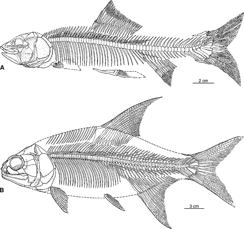
Within the limestones is preserved a fossil record of shallow marine communities of foraminifera such as Palorbitolina, Mesorbitolina and Praeorbitolina, rudists, corals, echinoids, crinoids and calcareous algae. Interestingly, microbial structures such as Lithocodium and Bacinella do indicate localised bioevents linked to nutrient fluctuations and sea level rise and fall. There are rare vertebrate fossils of blue-boned albuliform fish Baugeichthys caeruleus and the shark teeth from Sphenodus that indicate a limited ecological diversity living on or near the carbonate platform of this part of the Early Cretaceous Tethys.
The Bauges Massif has been shaped by intense Alpine deformation and long-term erosion. Around 30 to 40 million years ago during the Oligocene to early Miocene the Alpine orogeny uplifted and folded the region’s marine sedimentary rocks into a series of synclines and anticlines while powerful thrust faults pushed vast rock sheets westward. This complex tectonic activity produced the distinctive north–south ridges and perched synclines. During the Quaternary, glaciers carved broad U-shaped valleys and steep headwalls, while post-glacial rivers and karst processes continue to shape the limestone plateaux, forming caves, gorges and resurgent springs that characterise the Bauges landscape. The Urgonian Limestone provides a valuable record of an Early Cretaceous palaeoenvironment where sediments, reef ecology and climatic change shaped the northern Tethyan margin long before the uplift of the Alps.


