


Discover France and Explore the Fossils & Geodiversity of the Réseau des Grands Sites de France
- Wayne Munday
- Dec 6, 2025
- 18 min read
Updated: Dec 15, 2025
Sip back and discover France and explore the fossils and geodiversity of the Réseau des Grands Sites de France or Grands Sites de France a network of some of France’s most iconic and protected landscapes celebrated for their geodiversity, biodiversity and cultural heritage. Rooted in over a century of conservation law, including the landmark 1930 legislation safeguarding natural sites of artistic, historical, and scientific importance, these areas reflect the French nation’s enduring commitment to preserving exceptional landscapes. High visitor numbers, however, present challenges that legislation alone cannot address, prompting the development of the Grand Site de France programme a national framework focused on sustainable management, landscape restoration, and high-quality visitor experiences.

The prestigious Grand Site de France designation is awarded Ministry for the Environment and recognises sites that exemplify careful stewardship, landscape enhancement, and responsible public access. Complementing this initiative is the Réseau des Grands Sites de France was established in 2000 to connect designated sites with those aspiring to achieve the same standards. By fostering collaboration among local authorities, conservation experts, and communities, the network supports knowledge sharing, innovative preservation practices, and sustainable tourism across France’s most treasured natural environments.
Through this integrated approach the Grand Site de France programme and its current network of members and aspiring members this organisation is working towards ensuring that landscape such as dramatic limestone gorges and volcanic plateaus to estuaries, marshes, and coastal cliffs are protected, restored and celebrated.

The Réseau des Grands Sites de France looks to balance conservation with visitor engagement and responsible economic development, these initiatives safeguard France’s geological and cultural heritage, offering a model of sustainable tourism that preserves the country’s most remarkable landscapes for generations to come. The Grand Site de France Members include:
Aven d’Orgnac - Ardèche - Auvergne–Rhône-Alpes
Aven d’Orgnac, located near the Gorges de l’Ardèche in Auvergne–Rhône‑Alpes, is one of France’s premier karst cave systems and the only underground site to hold the prestigious Grand Site de France label. Carved into Cretaceous limestone around 100 million years ago, the cave features vast chambers adorned with thousands of speleothems, including stalactites, stalagmites, and flowstones, which record millennia of karstification, groundwater flow and climatic change.

Discovered scientifically in 1935, Aven d’Orgnac also hosts the Cité de la Préhistoire, showcasing Acheulean and Levallois stone tools that document human occupation spanning hundreds of thousands of years. While fossils and dinosaur remains are absent, the site’s geological and palaeoenvironmental significance is immense, offering insight into limestone plateau formation, post‑depositional karst processes, and underground landscape evolution. Since being awarded the Grand Site de France label in 2004, with renewals in 2010, 2017, and 2024, Aven d’Orgnac has maintained a focus on sustainable conservation, visitor engagement, and the protection of its extraordinary subterranean and archaeological heritage.
Visit Auvergne–Rhône-Alpes Tourism | Visit Ardèche Tourism
Baie de Somme - Somme - Hauts-de-France
Baie de Somme, located in the Hauts-de-France region, is one of Europe’s most remarkable coastal wetlands, spanning nearly 7,200 hectares where the River Somme meets the English Channel. Recognised as a Grand Site de France in 2011, with its label renewed in 2018, the bay exemplifies the dynamic interplay of marine, fluvial, and aeolian processes that have shaped its Holocene and late Quaternary landscapes.

Its extensive mudflats, dunes, salt marshes, and tidal channels record post-glacial transgressions and ongoing coastal evolution, while supporting globally significant habitats for migratory birds and unique estuarine flora such as Salicornia (Pickle Weed, Glasswort) a succulent, halophytic (salt tolerant) flowering plant. Although vertebrate fossils are absent due to its young geological age, Baie de Somme provides a living model for understanding sedimentary processes, estuarine ecology, and Holocene climate variability. Celebrated for its cinematic landscapes where land, sea, and sky merge, the site is a premier ecotourism destination, promoting soft mobility and sustainable visitation. The Grand Site de France designation reflects the long-term commitment of local stakeholders to preserve its ecological, cultural, and geological heritage for future generations.
Visit Hauts-de-France Tourism | Visit Somme Tourism
Bibracte Morvan des Sommets - Bourgogne-Franche-Comté
Bibracte Morvan des Sommets, situated in Bourgogne-Franche-Comté across Nièvre and Saône-et-Loire, is a unique intersection of geological, archaeological, and cultural heritage. Dominated by Mont Beuvray at 821 meters, this upland terrain lies within the Parc naturel régional du Morvan and was designated a Grand Site de France in 2007, with renewals in 2014 and 2022. Geologically, the Morvan is a granitic massif formed during the Variscan orogeny over 300 million years ago, later shaped by erosion and glaciation into rugged summits such as Haut Folin.

Unlike nearby sedimentary basins, its crystalline bedrock preserves no dinosaur fossils, but deeply weathered granite supports diverse soils, forests, and human settlement. Archaeological excavations at Bibracte reveal Iron Age oppida, Roman artefacts, and traces of the Eduens’ capital, illustrating how human history overlays ancient geology. Today, the site integrates sustainable landscape and forest management with community engagement, while the on-site research centre and museum provide insight into both natural and cultural evolution. Bibracte Morvan des Sommets exemplifies the convergence of deep-time geology and millennia of human heritage.
Visit Bourgogne-Franche-Comté Tourism | Visit Bibracte
Camargue Gardoise - Gard - Occitanie
Camargue Gardoise, located in the Gard department of Occitanie in southern France, is a remarkable landscape at the confluence of the Rhône delta and the Mediterranean Sea. Recognised as a Grand Site de France in 2014, with its label renewed in 2023, the area forms part of the UNESCO Camargue Biosphere reserve, highlighting its ecological, geological, and cultural significance. The region’s Quaternary and Holocene sediments record post-glacial sea-level rise, lagoon formation, salt marshes, and alluvial plains shaped by tidal incursions, flooding, and aeolian processes.
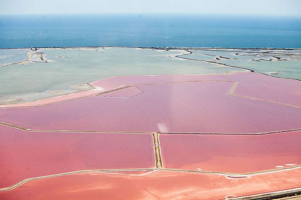
While dinosaur fossils are absent due to the young geological age, the wetlands preserve rich palaeoecological archives, including fossil pollen, mollusc shells, and plant macrofossils, offering insights into Holocene climate change and human impacts. Today, Camargue Gardoise combines thriving biodiversity with traditional land uses such as bull grazing, while restoration projects at sites like the Aigues-Mortes ramparts, Tour Carbonnière, and Espiguette dune massif demonstrate exemplary landscape management. The Visitor Centre enables visitors to explore the delta’s natural and cultural heritage, showcasing an evolving coastal environment that unites scientific value, conservation, and sustainable tourism.
Visit Occitanie Tourism | Visit Gard Tourism
Cap d’Erquy–Cap Fréhel - Côtes-d’Armor - Brittany
Cap d’Erquy–Cap Fréhel, located on Brittany’s Côtes d’Armor near Erquy and Fréhel, is a striking Grand Site de France renowned for its dramatic pink sandstone cliffs, Atlantic heathlands, and coastal biodiversity. The headlands expose Ordovician Armorican sandstones, deposited around 470–460 million years ago and later folded and fractured during the Variscan orogeny, while dolerite dykes and diorite intrusions, such as at Fort La Latte, punctuate the Paleozoic basement. Marine erosion, storm waves, and salt weathering have sculpted cliffs up to 70 metres high, forming stacks, pocket beaches, and rugged headlands.

Subtle Ordovician fossils, including Skolithos burrows, ripple lamination, and marine invertebrate fragments, reveal a dynamic shallow marine palaeoenvironment, though no Mesozoic dinosaur remains occur here. Today, the GR34 coastal path called the “Customs Officers' Path” winds through gorse- and heather-covered landscapes, linking natural scenery with cultural heritage, including Fort La Latte and the Cap Fréhel lighthouses. Awarded the Grand Site de France label in 2019, the site reflects over two decades of sustainable management, protecting fragile coastal ecosystems, enhancing biodiversity, and highlighting the interplay of Ordovician geology, Variscan tectonics, and ongoing Atlantic coastal processes.
Visit Brittany Tourism | Visit Côtes-d’Armor Tourism
Chaîne des Puys – Puy de Dôme - Auvergne–Rhône-Alpes
The Chaîne des Puys – Puy de Dôme, located near Clermont-Ferrand in Auvergne–Rhône-Alpes, is a UNESCO World Heritage Site and a premier Grand Site de France, celebrated for its exceptional volcanic geology. This Quaternary volcanic chain illustrates continental rifting and intraplate volcanism, with eruptions dating from 95,000 to 8,600 years ago, shaping a landscape of cinder cones, maars, domes, and lava flows. Puy de Dôme, a 1,465-meter trachytic dome, dominates the chain, offering a vivid example of explosive phreatomagmatic and effusive processes, later sculpted by erosion, tectonics, and glaciation.

Although fossils and dinosaur remains are absent due to the young volcanic rocks, Holocene soils and pollen archives provide insights into post-eruption vegetation recovery and climatic fluctuations. The Grand Site de France designation, first awarded in 2008 and renewed in 2014 and 2021, has enhanced sustainable tourism through hiking trails, restored facilities, unified signage, and an electric rack railway. A dedicated Site Visitor Centre and year-round cultural and environmental programming allow visitors to explore the dynamic volcanic landscape, combining Earth science education, geotourism, and conservation of one of Europe’s most iconic volcanic ensembles.
Visit Auvergne–Rhône-Alpes Tourism | Visit Clermont Auvergne Volcans | Visit Puy de Dôme
Cirque de Navacelles - Gard and Hérault - Occitanie
The Cirque de Navacelles, straddling the Gard and Hérault departments in southern France’s Occitanie region, is a striking example of karstic and fluvial geomorphology within the southern Massif Central. Carved into Jurassic limestones deposited 160–170 million years ago, the cirque was uplifted during Alpine tectonics and sculpted by the River Vis through meander cut-offs, headward erosion, and karst processes, forming an amphitheatre nearly 300 meters deep.

Its limestone strata preserve abundant marine fossils, including ammonites and bivalves, providing palaeoecological insights into Jurassic shallow seas, though dinosaur remains are absent. Holocene human occupation is visible on the terraces, reflecting the long interaction of people with this dynamic landscape. Cirque de Navacelles combines exceptional geological heritage with cultural and agropastoral landscapes, including sinkhole cultivation, lavognes or traditional, man-made stone-lined small reservoirs and traditional farmsteads. Visitor infrastructure enhancements and educational programs now allow 250,000 annual visitors to explore its dramatic cliffs, deep gorges, and evolving limestone terraces, showcasing both Earth history and sustainable heritage tourism in southern France.
Visit Occitanie Tourism | Visit Hérault Tourism
Conca d’Oru, Vineyard of Patrimonio–Gulf of Saint-Florent - Haute-Corse - Corsica
Conca d’Oru, overlooking the Golfe de Saint Florent in northern Corsica near Bastia, is a remarkable geological and cultural landscape anchoring the renowned Patrimonio vineyards. Shaped by Miocene to Quaternary sedimentary sequences deposited over the last 23 million years, the valley records tectonic uplift, Alpine thrusting, and erosional processes that produced limestones, marls, and alluvial fans ideal for viticulture. Its carbonate- and clay-rich soils preserve microfossils such as mollusks and foraminifera, offering insights into Neogene coastal environments.

While dinosaur remains are absent, Holocene archaeological traces and rich local biodiversity highlight the valley’s living heritage. The Patrimonio AOC, established in 1968, thrives on these ancient geological substrates, linking viticulture directly to Corsican identity. The six hills of Mont Sant’Angelo frame the vineyards with iconic sea views, while local initiatives promote organic wine production, landscape conservation, and a dedicated wine route. Recognised as a Grand Site de France in 2017, with the label renewed in 2024, Conca d’Oru exemplifies the intersection of geology, heritage, and sustainable viticulture in Corsica.
Visit Corsica Tourism | Visit Haute-Corse Tourism
Concors–Sainte-Victoire - Provence-Alpes–Côte d’Azur – Bouches-du-Rhône and Var
Concors–Sainte Victoire, spanning the Bouches-du-Rhône and Var departments in Provence-Alpes-Côte d’Azur, frames the iconic Montagne Sainte-Victoire northeast of Aix-en-Provence. Protected as the Sainte Victoire National Nature Reserve since 1994 and listed on the IUCN Green List in 2021, this massif is renowned for the Roques Hautes fossil site, where late Cretaceous Argiles et Grès à Reptiles Formation (Campanian–Maastrichtian, ~83–66 Ma) preserves dinosaur eggs and nests in situ.

These clay-sand deposits record fluvial-lacustrine processes on a gently subsiding basin, later shaped by Alpine uplift, folding, and erosion into limestone escarpments, karst basins, and valleys. The landscape integrates deep-time sedimentology, tectonic history, and cultural heritage, with forest, agricultural, and pastoral practices creating a classic Provençal scene. Recognised as a Grand Site de France in 2004 and renewed in 2020, Concors–Sainte Victoire exemplifies geotourism, Earth science education, and the intersection of natural heritage, conservation, and regional identity.
Visit Bouches-du-Rhône Tourism | Visit Var Tourism | Visit Côte d’Azur Tourism
Dunes Sauvages de Gâvres à Quiberon - Morbihan - Brittany
The Dunes Sauvages de Gâvres à Quiberon, along Brittany’s Morbihan coast, form the largest continuous dune massif in the region, stretching 25–35 km from the presqu’île de Gâvres to Saint Pierre Quiberon. Designated a Natura 2000 site and recognized as a Grand Site de France in 2018, this striking coastal landscape features foredunes, parabolic dunes, salt marshes, back-barrier lagoons, and rugged cliffs, largely free from urban development. Shaped by Atlantic winds, tides, and storm surges, the dunes and wetlands record Quaternary to Holocene coastal evolution, including post-glacial sedimentation, aeolian transport, and episodic overwash, with diagenesis stabilising older ridges and ongoing erosion sculpting the Côte Sauvage.

While fossils are rare due to the young, high-energy environment, shell fragments, pollen, and microfauna provide palaeoecological insights into recent climate and sea-level changes. The site’s exceptional biodiversity, rare flora, and dynamic geomorphology are preserved through careful management, balancing dune mobility, ecosystem protection, and visitor access, making the Dunes Sauvages de Gâvres à Quiberon a premier destination for geotourism, coastal science education, and sustainable landscape stewardship in Brittany.
Charente Estuary – Arsenal of Rochefort (Nouvelle-Aquitaine – Charente-Maritime)
The Charente Estuary – Arsenal of Rochefort, situated in Charente-Maritime within Nouvelle-Aquitaine, exemplifies the intersection of geology, maritime history, and cultural heritage. Recognized within France’s national heritage framework and UNESCO’s Atlantic coastal conservation network, the estuary records Holocene coastal evolution across Quaternary deposits formed over the past 10,000 years. Post-glacial sea-level rise shaped tidal flats, salt marshes, and alluvial terraces, while diagenesis and ongoing erosion continually sculpt the estuarine landscape. Fossils are limited, but mollusc shells, pollen, and microfauna preserve palaeoecological evidence of climate change and human influence. Dinosaurs are absent, yet archaeological remains and rich biodiversity—including migratory birds and estuarine fish highlight the area’s vertebrate heritage. The 17th-century Arsenal of Rochefort was strategically built on these stable terraces, linking geology to naval engineering and France’s maritime power. Today, the estuary, awarded the Grand Site de France label in 2020, balances conservation, sustainable tourism, and heritage restoration. Its mosaic of marshes, islands, tidal flats, and farmland offers visitors a unique window into coastal geomorphology, human ingenuity, and the evolving landscapes of Atlantic France.
Dunes de Flandre - Bray-Dunes and Zuydcoote - Hauts-de-France
The Dunes de Flandre, stretching across the windswept coastline of Bray-Dunes and Zuydcoote in Hauts-de-France, represent a dynamic North Sea dune system shaped by continual coastal processes. Situated at France’s northeastern margin near the Belgian border, this landscape is defined not by deep geological exposures but by the active interaction of wind, waves, and shifting sands that build and remodel the dunes over time.

With no preserved fossils, vertebrate remains, or dinosaur material typical for highly mobile dune fields the Dunes de Flandre instead offer insight into contemporary coastal dynamics, storm influence, and shoreline evolution. As a result, their significance is rooted in present-day environmental processes and coastal heritage rather than long-term geological or palaeontological archives.
Gorges de l’Hérault - Occitanie
The Gorges de l’Hérault in Occitanie, southern France, form a dramatic limestone canyon carved by the Hérault River between Saint-Guilhem-le-Désert, Laroque, and Ganges. Awarded the Grand Site de France label in 2010 and renewed in 2018, the area is celebrated for its exceptional Mediterranean landscapes and rich geological heritage. The gorge’s steep walls record a long history that began in the Mesozoic, when Jurassic and Cretaceous carbonate platforms accumulated in a warm shallow sea.

These limestones were later buried, gently folded by Alpine-related tectonics, and deeply incised by ongoing fluvial erosion. Fossils of ammonites, bivalves, and marine reptiles are preserved as calcite-filled molds within the strata, reflecting the region’s ancient marine origins. No dinosaur remains occur here, consistent with its exclusively marine depositional environment. Today, the canyon frames the medieval village of Saint-Guilhem-le-Désert, a major stop on the Way of St. James, offering a rare blend of geological significance, cultural heritage, and scenic beauty. Future priorities focus on landscape conservation, restoration of historic architecture, and enhanced visitor services to safeguard this renowned Mediterranean landmark.
Îles Sanguinaires – Pointe de la Parata - Corse-du-Sud - Corsica
The Îles Sanguinaires and Pointe de la Parata, forming a rocky chain at the northern end of the Gulf of Ajaccio in Corse-du-Sud, are among Corsica’s most striking coastal landmarks. Awarded the Grand Site de France label in 2017 and renewed in 2024, the area is celebrated for its dramatic Mediterranean scenery and its deep-time geological heritage. The islands are built from Late Paleozoic granites and volcanic-derived rocks, emplaced around 300 million years ago during the Hercynian orogeny and later uplifted, fractured, and sculpted by tectonic activity, wave erosion, and Quaternary sea-level fluctuations.

As crystalline igneous bedrock, these formations contain no fossil record or dinosaur remains, but they reveal the internal structure of an ancient mountain belt through prominent jointing, sharp coastal cliffs, and contrasts with surrounding softer strata. The landscape is further enriched by 18th- and 19th-century towers, lighthouses, and signal stations that once guarded the entrance to Ajaccio Bay. Today, expanding visitor facilities including new trails, a visitor centre, restored heritage structures, and shuttle access support sustainable tourism while preserving the exceptional natural and cultural character of this iconic Corsican site.
Les Deux Caps Blanc-Nez and Gris-Nez - Pas-de-Calais - Hauts-de-France
Les Deux Caps – Cap Blanc-Nez and Cap Gris-Nez, stretching between Boulogne-sur-Mer and Calais in Hauts-de-France (Pas-de-Calais), form one of northern France’s most iconic coastal landscapes and have held the Grand Site de France label since 2011. The two headlands showcase a striking geological contrast that reveals more than 100 million years of Earth history. Cap Blanc-Nez is composed of bright Upper Cretaceous chalk deposited 90–70 million years ago in a warm epicontinental sea, preserving rich marine fossils such as ammonites, inoceramid bivalves, sponges, and foraminifera, along with occasional shark teeth and marine reptile fragments.

To the south, Cap Gris-Nez exposes older Jurassic sandstones and mudstones dating to 170–160 million years, strata gently folded by later tectonic phases and sculpted into rugged cliffs by persistent coastal erosion. Interspersed with eight villages across a twenty-kilometre stretch, the site is managed to balance sensitive natural environments with agricultural activity and sustainable territorial development. The complementary geology of chalk and sandstone, combined with its dramatic Channel views and dynamic landscapes, makes Les Deux Caps a nationally significant geoscientific and cultural landmark.
Marais Poitevin (Nouvelle-Aquitaine and Pays de la Loire – Charente-Maritime, Deux-Sèvres, Vendée)
The Marais Poitevin, spanning Nouvelle-Aquitaine and Pays de la Loire across Charente-Maritime, Deux-Sèvres, and Vendée, is a distinctive Holocene coastal wetland often called the “Green Venice” was shaped by marine incursions, tidal sedimentation, peat formation and centuries of human drainage and reclamation. Designated a Grand Site de France in 2010 (label renewed 2018), the marshland is valued for its ecological, geological and cultural heritage and for sustainable landscape stewardship that supports livestock farming, restored water-related village heritage, and nature-based tourism.

Its Quaternary sediments preserve pollen, plant macrofossils, molluscs and microfauna that record post-glacial sea-level rise and the transition from marine to brackish and freshwater environments; because it is a recent, sedimentary wetland, no dinosaur or deep-time vertebrate fossils occur in situ. Current management priorities include habitat resilience, gradual replacement of vulnerable ash trees, and planning for future landscapes that balance conservation with local agricultural livelihoods and recreational use.
Massif du Canigó - Pyrénées-Orientales - Occitanie
The Massif du Canigó, rising in the Pyrénées-Orientales of Occitanie, southern France, is a prominent landmark of the eastern Pyrenees near Prades and Vernet-les-Bains. Awarded the Grand Site de France label in 2012 (renewed 2018), the massif is celebrated for its geological, ecological, and cultural significance, forming a symbolic boundary between Mediterranean and Pyrenean landscapes. Geologically, Canigó exposes a complex assemblage of Paleozoic and Mesozoic rocks, including metamorphosed granites, gneisses, and schists emplaced during the Hercynian orogeny around 300–350 million years ago.

Later Alpine tectonics, combined with Quaternary glacial and fluvial erosion, sculpted its rugged peaks and deep valleys. While steep lithologies limit fossil preservation and no dinosaur remains are known, scattered marine invertebrates and microfossils in surrounding sedimentary units provide insight into ancient environments. Beyond its geology, Canigó supports high-altitude Mediterranean flora and fauna and embodies Catalan cultural heritage. The massif’s mining history, abbeys, and priories, along with sustainable tourism initiatives, enhance visitor engagement while protecting its dramatic landscapes, making it a vital site for Earth Science research, ecological study, and cultural exploration in the eastern Pyrenees.
Pointe du Raz in Cap Sizun - Finistère - Brittany
The Pointe du Raz, at the western tip of the Cap Sizun peninsula in Finistère, Brittany, France, is one of the region’s most iconic and dramatic coastal landscapes. Awarded the Grand Site de France label in 2004, the headland is celebrated for its geological, ecological, and cultural significance. Composed of Early Paleozoic gneisses, schists, and granitic intrusions formed 500–450 million years ago during the Cadomian orogeny, the massif was later uplifted and reworked during the Variscan orogeny. Prolonged coastal erosion has sculpted its sheer cliffs, wave-cut platforms, and isolated rock stacks.

Because Pointe du Raz exposes crystalline bedrock rather than sedimentary basins, fossils and dinosaur remains are absent, making its scientific value lie in understanding orogenic processes, metamorphic textures, and structural geology. The surrounding Cap Sizun features wild heaths, bocage farmland, and preserved villages, integrating cultural heritage and local agricultural practices with sustainable tourism initiatives. The combination of panoramic Atlantic views, rugged cliffs, and specialized coastal flora and seabird colonies makes Pointe du Raz a compelling destination for geoscientists, ecologists, and visitors seeking both natural and cultural insights into Brittany’s unique coastal environment.
Puy Mary – Volcan du Cantal - Cantal - Auvergne–Rhône-Alpes
The Puy Mary, located at the heart of the Volcan du Cantal massif in Cantal, Auvergne–Rhône-Alpes, France, is one of the most striking remnants of Europe’s largest stratovolcano. Recognized for its geological, ecological, and scenic significance, the site was awarded the Grand Site de France label in 2012, renewed in 2019, and is situated within the Parc Naturel Régional des Volcans d’Auvergne, which promotes conservation and sustainable tourism. Formed during the Miocene to Pliocene (approximately 6–2 million years ago) through extensive effusive and explosive eruptions, Puy Mary’s basaltic and andesitic lavas and interbedded pyroclastic deposits were later sculpted by tectonic uplift, Quaternary glacial carving, and fluvial erosion, producing its iconic pyramidal peak, deep valleys, cirques, and star-shaped ridges.

Due to its igneous volcanic composition, the massif preserves no fossils or dinosaur remains, but its lava flows and pyroclastic layers provide vital evidence of ancient eruptive environments and stratovolcano evolution. Ecologically, Puy Mary supports high-altitude grasslands, endemic flora, and diverse wildlife. The Grand Site designation has facilitated preservation, local service support, and car-free exploration through shuttles and electric bikes. With panoramic views across the Massif Central and well-preserved volcanic structures, Puy Mary remains a premier destination for geologists, hikers, and nature enthusiasts drawn to its dramatic landscapes and geological heritage.
Solutré Pouilly Vergisson - Saône-et-Loire - Bourgogne-Franche-Comté
The Solutré-Pouilly-Vergisson site, situated in Saône-et-Loire, Bourgogne-Franche-Comté, France, is a globally significant geological and archaeological landmark in the Mâconnais Hills near Solutré and Pouilly-sur-Saône. Awarded the Grand Site de France label in 2013, the area is celebrated for its striking limestone escarpments, particularly the iconic Roche de Solutré, and its rich cultural and natural heritage. Geologically, the cliffs expose Upper Jurassic to Lower Cretaceous limestones (approximately 160–140 million years old), formed in a warm, shallow epicontinental sea and later lithified. Alpine tectonics, gentle folding, and long-term fluvial and slope erosion sculpted the dramatic ridges of Solutré, Pouilly, and Vergisson, creating the prominent landscape visible today.

While no dinosaurs are known from the site, its Upper Paleolithic archaeological deposits preserve extensive remains of reindeer, horse, and bison, offering vital insight into late glacial ecosystems and human subsistence over 57,000 years. Today, the site integrates vineyards, panoramic trails, and natural habitats, with sustainable management initiatives including reintroduced grazing, restored rural heritage, and reorganized footpaths. Solutré-Pouilly-Vergisson thus provides a unique convergence of Earth history, archaeological significance, and ecological conservation, making it a key destination for geologists, archaeologists, and culturally minded visitors alike.
Vallée de la Vézère – Dordogne - Nouvelle-Aquitaine
The Vallée de la Vézère, situated in Dordogne, Nouvelle-Aquitaine, France, is a globally significant valley celebrated for its exceptional geological and Paleolithic heritage, earning UNESCO World Heritage status in 1979 and the Grand Site de France label in 2020. Carved through Upper Jurassic limestones deposited 160–145 million years ago in a warm, shallow epicontinental sea, the valley’s dramatic cliffs and terraces were shaped by Alpine tectonic folding and Quaternary fluvial incision, exposing a remarkable sequence of prehistoric caves and rock shelters.

The site preserves one of Europe’s richest Paleolithic records, spanning 400,000 years, including engraved bones, cave art, stone tools, and extensive vertebrate assemblages such as reindeer, bison, mammoth, horse, and cave bear, providing vital insights into Late Quaternary ecosystems and human subsistence strategies. While no dinosaurs are present, the valley’s limestone and karstic environments reveal critical information about sedimentary processes, landscape evolution, and deep-time geology. Today, the Vézère Valley, set within the Périgord Noir, combines colorful agricultural landscapes, meandering rivers, and dramatic cliffs, offering visitors and researchers a unique opportunity to explore the interplay of geology, archaeology, and cultural heritage in one of France’s most iconic prehistoric landscapes.
Gorges du Tarn, de la Jonte et Causses - Lozère and Aveyron - Occitanie
The Gorges du Tarn, de la Jonte, and surrounding Causses, located in Lozère and Aveyron, Occitanie, southern France, form a striking karstic landscape renowned for its geological, ecological, and cultural significance. This area, awarded the Grand Site de France label in 2024, showcases dramatic limestone cliffs, deep river gorges, and extensive carbonate plateaus, sculpted over millions of years. The exposed Jurassic limestones (approximately 200–145 million years old) were originally deposited in warm, shallow epicontinental seas, later buried, lithified, and gently folded during Alpine tectonic events. Subsequent fluvial incision by the Tarn and Jonte rivers, along with karstification, cliff retreat, and Quaternary erosion, carved the sheer gorges and preserved the surrounding Causses plateaus, highlighting ancient depositional surfaces and karstic features.

While no dinosaurs are recorded in this predominantly marine and karstic region, the gorges contain rich fossil assemblages of ammonites, bivalves, brachiopods, and marine reptiles, often preserved as calcite-filled molds and impressions, providing valuable insight into Jurassic marine ecosystems. Today, the Gorges du Tarn and de la Jonte attract geologists, palaeontologists, and nature enthusiasts eager to explore the interplay of tectonics, erosion, and fossil-rich marine strata, all within a carefully managed landscape that balances conservation, sustainable tourism, and local economic support.
Salagou – Cirque de Mourèze - Hérault - Occitanie
The Salagou–Cirque de Mourèze, located in Hérault, Occitanie, southern France, is a remarkable geological landscape renowned for its red clay badlands, karst towers, and striking limestone pinnacles. The site exposes Permian to Triassic sedimentary sequences, approximately 300–220 million years old, formed in arid floodplains and shallow lake environments during the late Paleozoic and early Mesozoic.

Subsequent tectonic uplift, fracturing, and millennia of fluvial and wind erosion sculpted the angular limestone towers of the Cirque de Mourèze and the vibrant red clays of the Salagou Formation. Fossils are rare in these continental deposits, and no dinosaurs are recorded; however, plant remains and trace fossils provide insight into Permian–Triassic terrestrial ecosystems. Awarded the Grand Site de France label in 2024, the site is celebrated for its diverse landscapes, vivid colours, and rich biodiversity, while management initiatives enhance visitor experience, preserve heritage, and support sustainable local practices. Salagou–Mourèze thus exemplifies post-depositional landscape evolution, tectonic influence, and the interplay of geology and natural beauty in southern France.

