


Discover Jamaica and Explore the Fossils & Geodiversity of the Caribbean and Greater Antilles
- 4 hours ago
- 7 min read
Jamaica stands at the heart of the Caribbean Sea along the active boundary between the Caribbean Plate and the North American Plate, preserving one of the Greater Antilles’ most complete geodiversity records. Ancient oceanic crust, volcanic island arcs, fossil rich limestones, and vast karst landscapes reveal more than 140 million years of tectonic movement, reef growth, uplift, and sea level change. The UNESCO Protected Area designation of Cockpit Country highlights this extraordinary heritage, where cone shaped hills, caves, underground rivers, and biodiversity intersect with deep cultural history. Together, Jamaica’s inliers, limestone plateau, fossil reefs, and cockpit karst terrain form a must-visit destination for geotourism in the Caribbean.

Jamaica occupies a pivotal geological and geographic position in the heart of the Caribbean Sea, south of Cuba and west of Hispaniola, straddling the active boundary between the Caribbean Plate and the North American Plate. Though modest in size at just 235 kilometres long the island preserves a valuable geological record of the Greater Antilles. From fragments of ancient oceanic crust and volcanic island arcs to fossiliferous tropical limestones and dramatic karst landscapes, Jamaica tells a story that spans more than 140 million years of Earth history. This extraordinary geodiversity gained international recognition in 2023, when west-central Jamaica’s Cockpit Country was designated an UNESCO Protected Area.
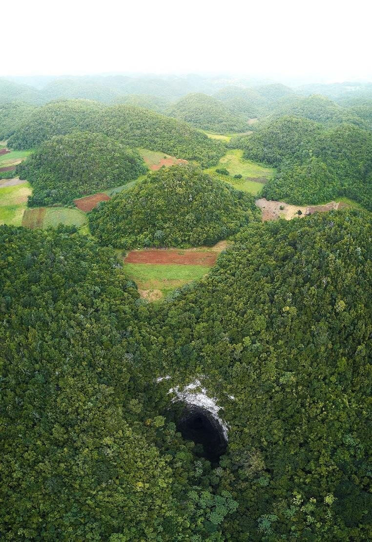
The Cockpit Country Protected Area represents one of Jamaica’s most extraordinary natural and cultural landscapes, shaped by more than 15 million years of limestone dissolution that created its iconic cone karst topography of steep hills, closed valleys, sinkholes, and vast cave systems. Spanning over 78,000 hectares across five parishes, this rugged “egg-carton” terrain forms Jamaica’s largest wet limestone forest and plays a critical hydrological role, supplying around 40% of underground freshwater resources to western parishes through interconnected aquifers, rivers, and caves. The region is a global biodiversity hotspot, hosting remarkable levels of endemism, including over 100 unique plant species, the island’s strongest populations of endemic parrots, diverse bat colonies occupying hundreds of caves, and high concentrations of endemic frogs, butterflies, and insects. Beyond its ecological value, Cockpit Country holds profound cultural heritage as a refuge for the Taíno people and later the Leeward Maroons, whose settlements, trails, and sacred caves supported resistance against colonial forces and led to the historic Maroon Treaty of 1739. Its dramatic karst landscape, rich biodiversity, extensive cave networks, and deep historical significance together establish Cockpit Country as one of the Caribbean’s most outstanding examples of tropical karst terrain and living cultural landscape.
Geologically, Jamaica rises from the Nicaraguan Rise, a broad zone of thickened crust stretching from Central America to the Greater Antilles. Immediately to the north lies the Cayman Trough, a deep tectonic basin separating Jamaica from Cuba and marking part of the strike-slip fault system between the Caribbean and North American plates. This tectonic setting has shaped the island’s evolution through compression, uplift, faulting, and volcanic activity since the Late Cretaceous. Over tens of millions of years, lateral plate movement combined with crustal shortening forced blocks of older rock upward, creating a series of “inliers” or areas of older rock completely surrounded by younger rock, typically formed when erosion, folding, or faulting removes overlying younger strata to expose Jamaica’s deep geological past. The most prominent of these include the Blue Mountain Inlier in the east and the Central Inlier near Clarendon, where pillow lavas, deep-marine sediments, and volcanic arc basalts preserve evidence of submarine eruptions on the floor of the proto-Caribbean Sea.

The proto-Caribbean Sea began forming around 180–160 million years ago during the Jurassic, when rifting within the supercontinent Pangaea split North America from South America and created a marine seaway between the two plates. As the continents continued to separate, deep ocean basins developed by the Middle Jurassic, establishing an early precursor to the modern Caribbean region. During the Cretaceous, the Pacific-derived Caribbean Plate migrated eastward into this space, initiating the formation of the Great Arc of volcanic islands and reshaping the seaway’s structure. By roughly 90–70 million years ago, collision and tectonic interaction between the Caribbean Plate and the proto-Caribbean crust profoundly altered the region, subducting much of the original seafloor. Today, the proto-Caribbean survives only in fragments beneath the Caribbean Plate, forming the geological foundation of the modern Caribbean Sea.
As tectonic activity gradually eased during the Paleogene Period, newly elevated crustal blocks subsided beneath warm, shallow tropical seas. These conditions triggered one of the most significant phases of carbonate deposition in the Caribbean. From the Late Eocene through to the Miocene, thick limestone sequences accumulated across most of the island, forming the White Limestone Group. Today, these limestones blanket nearly two-thirds of Jamaica and create the elevated plateau that defines much of the island’s topography. Built from the skeletal remains of corals, molluscs, calcareous algae, echinoids, and microscopic foraminifera, these ancient reef systems compacted and cemented through diagenesis into massive carbonate platforms that now rise hundreds of metres above sea level.
Beneath this limestone mantle lie older sedimentary and volcanic rocks grouped within the Yellow Limestone Group and the Cretaceous inliers. These sequences record alternating phases of volcanism, deep-marine sedimentation, and shallow carbonate platform growth during Jamaica’s early history as part of an evolving island arc system. Together, they preserve a remarkable fossil archive that reveals how tropical marine ecosystems responded to changing sea levels, volcanic activity, and tectonic uplift over geological time. Among the inliers is the Blue Mountain Inlier the largest of several Cretaceous inliers on the island, representing a complex, faulted area where older, metamorphic, and volcanic Cretaceous rocks (roughly 66-145 million years old) are exposed through younger Tertiary cover.

Among Jamaica’s most significant fossil treasures are the rudist bivalves giant reef-building clams that dominated tropical seas during the Late Cretaceous. Unlike modern clams, rudists developed massive, asymmetrical shells that often resembled corals in shape and function. Some species, such as the barrel-shaped Barrettia or the enormous Titanosarcolites giganteus, reached lengths of over a metre, making them among the largest molluscs to have ever lived. In Jamaica’s Central Inlier and other Cretaceous limestone exposures, rudists occur in dense reef frameworks that preserve entire ancient carbonate platforms frozen in time.

These fossil reefs provide rare insight into shallow tropical environments that thrived shortly before the end-Cretaceous mass extinction. While dinosaurs vanished on land and ammonites disappeared from the oceans, rudists declined earlier in the Caribbean, likely due to rapid subsidence and collapse of carbonate platforms triggered by tectonic instability and sea-level change. Their extinction reshaped reef ecosystems, allowing corals to once again dominate tropical carbonate systems in the Cenozoic Era.

Jamaica’s fossil record extends well beyond rudists. Cretaceous and Cenozoic rocks preserve corals, echinoids, crabs, ammonoids, foraminifera, and early marine vertebrates, including primitive sea cows such as Pezosiren the first known quadrupedal sirenian, known as the "walking manatee" and represents a transitional form between terrestrial and marine sirenians and Prorastomus a family of extinct sirenians related to the extant manatees and dugong.

Notably absent from Jamaica’s geological archive are dinosaurs. The reason lies in palaeogeography. For most of the Mesozoic Era, Jamaica existed as submerged volcanic arcs and marine carbonate platforms rather than large terrestrial landmasses. Sedimentation occurred almost entirely in oceanic and shallow-marine environments where land-dwelling dinosaurs did not live and where their remains were unlikely to be preserved. As a result, Jamaica’s ancient history is overwhelmingly marine in character.
The island’s modern landscapes are shaped by the dissolution of its vast limestone cover. Nowhere is this more dramatic than in Cockpit Country, a rugged karst terrain spanning parts of Trelawny, St Elizabeth, and St James parishes. Here, thousands of steep-sided limestone hills rise like giant cones, separated by enclosed depressions that create an “egg-carton” topography unlike anywhere else in the Caribbean. This terrain formed as slightly acidic rainwater percolated through fractures in the White Limestone Group, dissolving calcium carbonate and enlarging underground drainage networks over millions of years. Gradual surface lowering, cave collapse, and continued chemical weathering sculpted the spectacular cockpit karst landscape visible today.
Beneath Cockpit Country lies an intricate network of caves, underground rivers, sinkholes, and springs that regulate Jamaica’s freshwater supply and preserve both fossil remains and archaeological evidence of early human settlement. Limestone exposures within the geopark reveal stacked Eocene to Miocene reef sequences rich in corals, molluscs, and foraminifera, allowing scientists to reconstruct ancient sea-level fluctuations and reef evolution across tens of millions of years.
As Jamaica continued to uplift during the Neogene and Quaternary periods, erosion carved interior valleys such as St Thomas-in-the-Vale, while thick alluvial deposits accumulated from weathered inlier rocks and redistributed bauxite rich soils. Volcanic ash from major Central American eruptions settled across the limestone plateaux and was transformed through intense tropical leaching into bauxite now one of Jamaica’s most economically important mineral resources.
Along the island’s margins, raised coral reef terraces preserve snapshots of past sea levels over the last five million years. Each terrace represents a former reef that flourished during a warm climatic highstand before tectonic uplift elevated it above the modern shoreline. These coral limestones serve as precise markers for reconstructing Quaternary sea-level change and measuring ongoing uplift rates, confirming that Jamaica remains geologically active today.
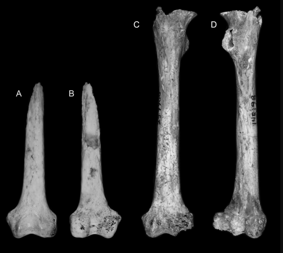
Karst caves also hold the key to Jamaica’s younger fossil history. Pleistocene cave deposits preserve extinct mammals such as the giant rodent called Osborn's Key Mouse (Clidomys osborni) the tree-dwelling monkey Xenothrix mcgregori or Jamaican monkey first uncovered at Long Mile Cave an extinct species of primate that is native to Jamaica and diverse bat species. Many skeletons occur in partially articulated condition within mudflow and flood sediments, indicating rapid burial during extreme weather events. These assemblages document how isolated Caribbean islands fostered unique evolutionary lineages that vanished soon after human arrival several thousand years ago.
Jamaica’s geodiversity showcases nearly every major process that shapes tropical islands, including submarine volcanism, plate collision, carbonate platform development, karst erosion, fossil reef formation, tectonic uplift, and climate-driven sea-level change. From ancient oceanic crust exposed in mountain inliers to expansive limestone plateaux carved into caves, sinkholes, and dramatic karst landscapes, the island serves as a natural laboratory for understanding Caribbean tectonics and tropical Earth systems. The UNESCO Global Geopark designation of Cockpit Country elevates Jamaica’s global importance in geoconservation and geotourism, highlighting the powerful interaction of geodiversity, ecosystems, and human history within a single dynamic region. For visitors Jamaica offers a living geological and fossil archive where over 100 million years of Earth history are preserved in stone, revealing the processes that built one of the Caribbean’s most diverse and visually striking natural environments.


