

Discover Canada and Explore the Fossils and Geodiversity of Cape Breton Island in Nova Scotia
- Oct 10, 2025
- 5 min read
Updated: Dec 19, 2025
Sip back and discover Canada and explore the fossils and geodiversity of Cape Breton Island situated in north eastern Nova Scotia and bordered by the Gulf of St. Lawrence and the Atlantic Ocean whose remarkable landscape dates back over a billion years. The island’s landscape including the Cape Breton Highlands, Bras d’Or Lake and the Sydney Coalfield rests upon four distinct terranes of the ancient Blair River Complex, the Ordovician–Devonian Aspy Terrane, the Precambrian-to-Cambrian Bras d’Or Terrane and the southern Mira Terrane of the Avalon group. These terranes have been sutured together through successive continental collisions before being uplifted during the Appalachian orogeny creating the rugged highlands and tropical Carboniferous swamps. The Sydney Coalfield, with twelve major coal seams of peat-rich deposits that transformed into high volatile bituminous coal over millions of years. Cape Breton is also renowned for its exceptional plant fossil record, including once towering Lepidodendron, Bothrodendron “scale trees,” Stigmaria root systems and an assemblage of ferns all curated at the Cape Breton Fossil Centre. Although dinosaur fossils are absent, rare 320 million-year-old anthracosaur tracks found near Creignish reveal the presence of large early vertebrates highlighting the island’s significance as a Late Paleozoic tropical swamp ecosystem and the Carboniferous biosphere.
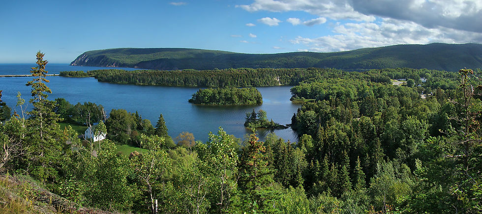
Cape Breton Island is located in the north eastern part of Nova Scotia separated from the mainland by the Strait of Canso which is bridged by the Canso Causeway. Surrounded by the Gulf of St. Lawrence to the north and west and the Atlantic Ocean to the east and south the island features a dramatic landscape that includes the Cape Breton Highlands and the inland saltwater body of Bras d’Or Lake. Its main communities are Sydney, Glace Bay, Sydney Mines and Baddeck. Along the southeastern coast, near Sydney Mines and Lingan, Carboniferous rock formations and coal seams define the historic Sydney Coalfield, a reminder of Cape Breton’s mining heritage.
Cape Breton Island tells a story that spans over a billion years of Earth’s history and whose landscape has been defined by the Cape Breton Highlands, the Bras d’Or Lakes and the Sydney Coalfield. All of which sit upon four ancient terranes of the Blair River Complex, Aspy Terrane, Bras d’Or Terrane, and Mira Terrane where each represents a distinct fragment of Earth’s crust with its own origin and age. Through successive continental collisions over time along with the slow and relentless forces of plate tectonics has sutured these terranes together sculpting the landscape that defines Cape Breton Island today.

The Blair River Complex or Blair River Inlier near Pleasant Bay forms the northern Cape Breton Highlands and has the island’s oldest rocks of gneiss, anorthosite and plutonic rocks formed during the Grenville Orogeny a major mountain building event that happened roughly 1.5 - 1.0 billion years ago and represents part of the ancient continental basement of North America during the late Mesoproterozoic to early Neoproterozoic when Laurentia or the North American craton other continental blocks such as Amazonia collided to close an ancient ocean and assemble the supercontinent Rodinia.
To the south east of Cape Breton Island is the Aspy Terrane of Ordovician to Devonian metavolcanic, metasedimentary and granitic rocks. Covering much of the central Cape Breton Island is the Bras d’Or Terrane of gneisses, granitic intrusions and sedimentary sequences metamorphosed during the late Precambrian to early Cambrian period. The remainder of the southern half of Cape Breton Island is made up of the Mira Terrane, part of the Avalon Terrane that features volcanic and sedimentary rocks intruded by Devonian plutons from the late Precambrian to Ordovician Period.

Over time, these terranes collided and fused to form Cape Breton Island to be later uplifted during the creation of the Appalachian Mountains around 325 million years ago. Tropical forests blanketed the region giving rise to the Sydney Coalfield spanning the Westphalian to Stephanian stages of the Late Carboniferous before erosion and glaciation sculpted today’s rugged highlands.
The Sydney Coalfield has at least twelve undisturbed major coal seams and is the largest of Cape Breton’s coal-bearing basins and extends along the island’s southeastern coast beneath towns of Sydney Mines, Glace Bay, Lingan and continues beneath the ocean floor where submarine coal seams are mined offshore. During the Carboniferous, Cape Breton lay near the equator and experienced a humid, warm tropical climate. Extensive peat-forming swamps developed across the Sydney Basin and were periodically submerged by floods and river sediment. Each new layer of sediment sealed organic debris beneath it cutting off oxygen and promoting peat accumulation. Over millions of years the combined effects of burial, compaction, heat, and pressure transformed the buried peat by the process of coalification into high-volatile A bituminous coal.
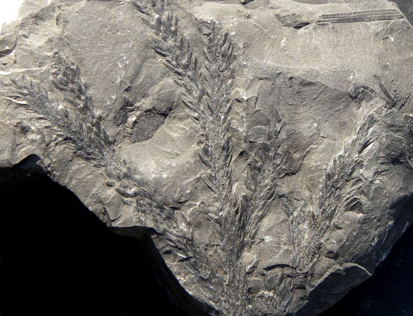
Cape Breton Island has long been recognised for its significant palaeobotanical fossil record. Sir Charles James Fox Bunbury, 8th Baronet (1809-1886), played a significant role in the study of Cape Breton Island’s palaeontology despite never actually visiting the region. His involvement came through correspondence and the analysis of fossil specimens sent to him, notably by Captain Richard Brown, who collected fossil plants from the coal. Bunbury meticulously documented these finds in his notes and manuscripts and this work advanced the understanding of Carboniferous palaeobotany particularly about the plant life of Nova Scotia’s coal fields.
The Cape Breton Island coal fields of Nova Scotia preserve one of the world’s most complete records of Carboniferous plant life. Within the Sydney Coalfield the coal seams contain preserved lycopsids, sphenopsids (Horsetail), ferns and seed ferns including the once towering Lepidodendron and Bothrodendron or “scale trees”. Their distinctive diamond-patterned bark and root systems called Stigmaria are often found in situ forming fossilised forests. Fossil sites such as Sydney Mines, Cranberry Point and Schooner Pond provide exceptional exposures while the Cape Breton Fossil Centre curates over 800 specimens, the largest Carboniferous plant collection in Atlantic Canada.

Although the coal measures predate the appearance of dinosaurs finding a vertebrate fossil is very rare and ordinarily limited to fragmentary evidence of early amphibians or small fish. However, recently geologists from Cape Breton University discovered a rare 320-million-year-old fossilised trackway near Creignish on the south west of the island. Dating to the Mississippian Age approximately 358.9 - 323.2 million years ago during the early part of the Carboniferous Period these large clawed tracks from an anthracosaur a crocodile-like transitional species between amphibians and reptiles have been found. Thought to have lived in the shallow tropical swamp waters this discovery is especially significant because Mississippian aged rocks are rarely exposed on Cape Breton Island because they are often concealed beneath layers of material from the Carboniferous Period. Large vertebrate traces of apex predators are extremely uncommon in Atlantic Canada.
Cape Breton is a key region for studying both ancient vertebrate life and the tropical swamp ecosystems of the Late Paleozoic. Its remarkable fossil assemblages offers a rare, detailed glimpse into the Carboniferous biosphere, shedding light on plant evolution in a tropical swamp forests during Earth’s major coal-forming age.


